By: Andrew Avitt, Oct. 28, 2021-
After burning for 69 days, 221,835 acres burned, 1,003 structures destroyed, and the evacuation of more than 50,000 residents in the area, the Caldor Fire is 100% contained. Now that the fire has ceased, it is time for residents and land managers to begin the process of restoration, to take stock and to reflect.
The devastating blaze impacted communities across the landscape. However, there were a few success stories where the intense flames met landscapes treated by federal, state and local land managers which allowed firefighters to get a foothold and control the fire’s spread.

One such instance occurred in late August at the southern edge of South Lake Tahoe, a mountain community of about 22,000 residents.
Despite suppression efforts, the Caldor Fire burned up and over Echo Summit, crossed a ridgeline, and continued to spread down into the Lake Tahoe Basin. A ridgeline like the one at Echo Summit ordinarily would have served as a strategic location, a point where firefighters might stop the flame’s advance. However, long-time firefighters will tell you ‘these days, wildland fires are far from ordinary.’ Exacerbated by drought and climate change, they can spread over hundreds of thousands of acres and burn with an intensity that once was uncommon.
Kyle Jacobson, a USDA Forest Service Fire Management Officer in the Lake Tahoe Basin, has worked in the area for 15 years, fighting fire and working to prevent extreme fire behavior.
“When the Caldor Fire came into Tahoe it was a crown fire. Hundred-foot flames were moving fast through the tree canopy,” Jacobson said. “The rate a fire like that moves and the heat it generates doesn’t allow firefighters to get close enough to directly suppress the flames.”

Very large fires, like the Caldor Fire, are not just characterized by the enormous areas of wildland they consume but also by the extreme behavior they exhibit. For example, these high-intensity fires can often create their own weather. As the air gets drawn into the fire, pyrocumulus clouds form in what looks like a column of smoke.
The upward draft in these clouds is strong enough to throw embers miles away, sparking new wildfires, commonly referred to as spot fires. High winds exacerbate the situation, creating unsafe conditions for firefighters to attack the fast-moving flames. Under these conditions, fires can burn so hot that retardant or water dropped by aircraft have little to no effect.
These are just some of the dangerous behaviors exhibited by an extreme wildfire that can limit strategies available to firefighters to suppress the flames, said Jacobson.
On the night of Aug. 16, when the Caldor fire was only three days old. the wind picked up, bending the flames northeast toward Lake Tahoe Basin, about 30 miles away. Fanned by the wind and fueled by dense, overstocked forests, the fire grew at unprecedented rates ranging from 10,000 to 40,000 acres per day.
At the time, fire modeling projected that in the coming days the fire would climb natural drainages running from the Pacific Ocean to Echo Summit overlooking Lake Tahoe.

On Aug. 30, when the Caldor Fire arrived in South Lake Tahoe, one subtle yet critically important factor helped firefighters defend homes and businesses – fuel treatments a decade in the making. Throughout the preceding decade, the Forest Service along with state and local land managers had been conducting forest management projects in the surrounding forests and, in doing so, had prepared for the oncoming Caldor Fire.
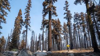
As the fire made its way down from Echo Summit it began to burn through areas where combustible materials had been reduced by mechanical thinning (the removal of trees from overstocked forests), and prescribed burns (controlled, low-intensity burns under favorable conditions to clear excess debris from the forest floor).
Jacobson helped plan and conduct many of the prescribed burns and mechanical thinning projects in the area that would later interact with the Caldor Fire. Less material available to burn tempered the fire’s extreme behavior, he said. The fire which had been swiftly moving across the treetops began to slow, and then drop down to the forest floor.

“We noticed that when the fire moved into those areas that were treated around neighborhoods in Christmas Valley, the fire intensity greatly diminished,” said Jacobson. “That gave firefighters the room they needed to safely suppress the flames potentially saving around 600 homes in that community.”
Many areas within the Caldor Fire had little or no fire history since the 1940s, which allowed for fuel to build up and eventually stoke the intense flames this year. Though the fire to date has destroyed 622 homes, 12 commercial real estate, and 177 small structures, no structures have been lost in South Lake Tahoe, in part due to the legacy of forest management that had been conducted over the years.

Reports from firefighters that defended the town that day tell a tale of two fires, the one that happened, how the fire slowed allowing firefighters room to work within a safe and defensible space, and the one that could have been, the one that could have continued to burn intensely and fast down the mountainside.
It is unknown what would have happened had the forest not been treated, but what is known is that there would have been a greater threat to the lives of firefighters, the community, and to property and infrastructure.
Many of the large fires occurring in California, Oregon and Washington this year experienced a similar series of events where prior mechanical thinning, prescribed fire, and past wildfires reduced fire intensity and provided firefighters with opportunities to protect communities. In California, more than 125 wildfires on Forest Service lands have encountered fuel treatments of some kind.
While fuel treatments will not stop the spread of wildfire in all situations, they are one of the best strategies available to improve forest health and lower threats to communities.
Nationwide, over 800 wildfires on national forests and grasslands have encountered fuel treatment areas. Data from these encounters indicate that 86% of the time the treatment helped reduce the intensity of fire behavior and bolstered suppression efforts.
In caring for the land, there is no substitute for wildland fire in fire-adapted forests. Almost a century of research has shown that low-intensity fire reduces fuel loading across landscapes, slowing large wildfires and diminishing their severity. Science has also shown that our treated landscapes need to cross jurisdictional boundaries because wildfire risk is an all-lands problem affecting multiple landownerships. Going forward, it is imperative that all landowners work together to conduct the right treatments in the right places at the right time and at the right scale.
For more information on what communities can do to reduce risk and mitigate the effects of severe wildfires please visit The Forest Service’s Wildfire Risk To Communities or Firewise USA.